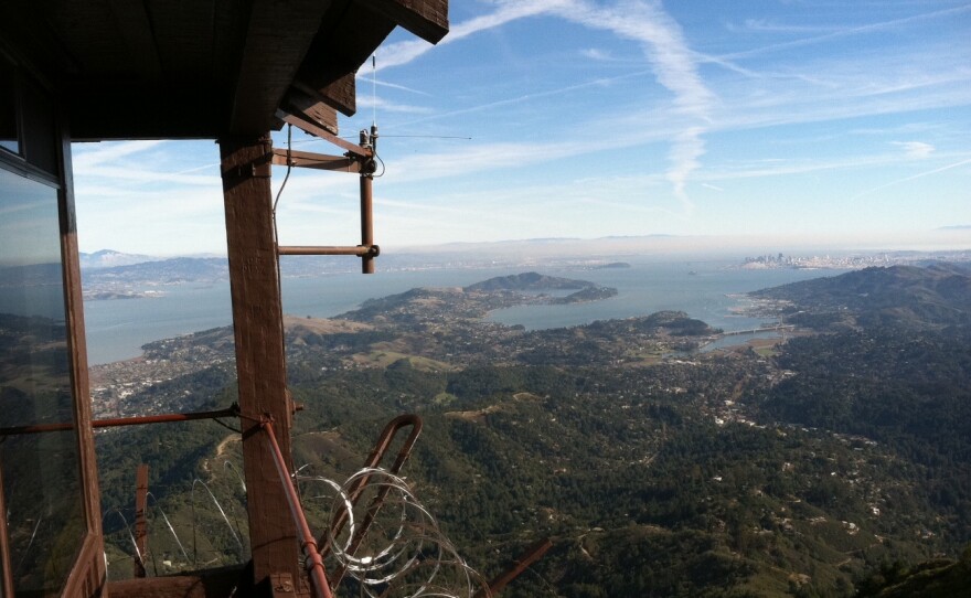
High above the Bay, at the top of Mount Tam, is a little shack—up on stone tower, just that much higher above the peak where it sits. It’s called the Gardner Lookout, and it’s one of two fire lookout towers in Marin County.
During the dry season, as many as 50 volunteer fire watchers take shifts in these outposts. They spend days and nights using old brass instruments, maps, a two-way radio, and a box of dog-eared 3x5 notecards to watch over you from a room with windows instead of walls.
I visited the lookout on Mt. Tam. to see what the fire watchers see. Up this high, above the fog line, there aren’t houses or corner stores or office towers.
“So you take your own food, but there’s plenty of water up there,’ says Gary Yost, a fire watch volunteer at the Gardner Lookout.
Besides the parking lot and the lookout, the only other man-made structures are an array of antennae and satellite dishes, and a white dome on a peak in the near distance. I ask Yost what they’re for.
“That’s microwave communications for cell phone companies and TV and radio stations, and corporate data networks,” he tells me. “High speed Internet stuff. And then that’s the FAA radar, from the Federal Air Traffic Control, radar. The airforce uses that, too.”
It makes a digital chatter – something I can hear through my headphones.
Above us, the sky is crisscrossed with an intricate array of long white airplane contrails, fading and drifting into the cloudless bright blue. Yost describes what’s below us.
“You can see here we’ve got the Corte Madera Ridge, and beyond it is Tiburon and Belvedere, Angel Island, Richmond Bay, and there’s San Quentin, and the Richmond Bay Bridge. It’s all just happening,” says Yost. “And you can barely hear a rumble of the traffic on 101. But you can hear it.”
We stand still, listening.
Yost laughs and whispers, “That’s the sound of seven million people.”
The low rumble of traffic. That’s the sound of the Bay Area.
What’s so special about this place is not just what you can hear, it’s what you can see. This is one of the best places in the Bay Area to spot fires.
The lookout building is a rugged tower—built of stone and wood, and ringed by a catwalk protected from intruders by rolls of gleaming razorwire.
“And it’s solid,” says Yost. “This door weighs 300 pounds. And the rock is two to three feet thick.”
That’s to keep it from burning in a fire.
Inside, in the base of the lookout, are shelves of supplies, a refrigerator, a shower stall. And a steep, narrow staircase with a warning sign that says, ‘Danger, climbing can cause severe injury.’
“I don’t think it’s the climbing that causes the injury, though,” jokes Yost. “It’s the falling part.”
We climb the ladder, and emerge into what Yost calls “the nicest room in the SF Bay Area.”
It’s breathtaking. On a clear day, you can see as far as 60 or 70 miles in all directions.
“So you’re looking for a column of smoke,” Yost tells me. “That’s all you’re looking for is a column of smoke.”
The fire watchers are the first to spot one or two fires every year. They also monitor the fires, and keep firefighters updated on how well containment efforts are working. To do that, first they have to figure out exactly where the fire is.
“If you see smoke, you use this thing here called the Osborn Fire Finder. Which is in every single fire lookout pretty much in the world,” Yost says.
The Osborn Fire Finder is a brass measuring device that looks like it could be a navigational instrument on an old sailing ship. It rotates above a circular map of the Bay Area—kind of like a flattened globe, perched on a tall tabletop at the center of the room. This is what volunteers like Yost use to pinpoint the location of a fire.
“It’ll tell you pretty much where on the vertical the fire is, and you put your eye in this little teeny tiny hole. I mean this hole is probably a 32nd of an inch across, and you line up one of those two crosshairs on the other side with the smoke, and you rotate the whole unit, which rotates very smoothly along a 360-degree marked base,” he says.
Once the volunteer gets the fire’s coordinates, he flips through “this really high tech, three by five card file. And we can see that there are these little landmarks that are listed on each one of these three by five cards,” says Yost.
The cards are well worn—some are typed, some are written in pen. They match up coordinates with landmarks. Once they pinpoint the fire’s location, the volunteers call it in on the two-way radio that is always on, chattering in the background.
During the day, the volunteers have lots of company. The summit of Mt. Tam. is a popular spot—people come for that spectacular view.
After dark and early in the morning, though, the volunteers have the mountain top all to themselves.
“The sunrise up here starts real early in the summer,” Yost tells me. “Four o’clock you can start to see light coming into the sky. And it lasts a long time. Maybe a two-hour sunrise. … And there’s all sorts of amazing visual effects that the rising sun has on the fog. If the fog is really really deep, you don’t see any of the lights of the Bay Area, but then the stars pop out like nobody ever sees the stars. The stars are as bright as the stars in the middle of the desert.”
A desert of seven million people. And one volunteer, perched on the mountaintop watching over us, looking for smoke.
Click the audio player above to hear the story.
http://vimeo.com/48169212


